The Churning Heart of Málaga: A Biography of the Guadalhorce
From the dizzying heights of the Caminito del Rey to the fertile citrus groves of the valley, the Guadalhorce is a river that has both fed and feared by the people of Málaga for millennia.
This story began with a question: “What is the story of Guadalhorce River?”
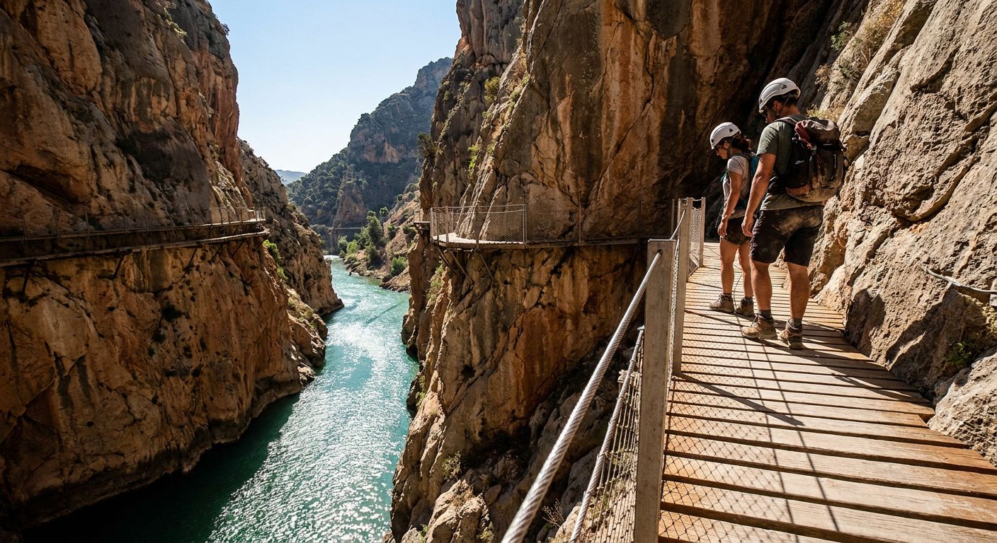
The view from the Caminito del Rey is not for the faint of heart. Suspended hundreds of feet above a limestone gorge, the walkway clings to the sheer cliffs of the Gaitanes Gorge, where the Guadalhorce River has spent millions of years carving its way through the bedrock. Below, the water churns, a turquoise vein slicing through the scorched, honey-colored mountains of Andalusia. This is the river’s dramatic peak, a place where geography and engineering collide, yet the story of the Guadalhorce begins far more quietly in the high plateaus of the Sierra de Loja and ends in a sprawling bird sanctuary on the edge of the Mediterranean.
It is a river of extremes. Depending on where you stand along its 166-kilometer journey, the Guadalhorce is a trickling stream, a violent torrent, a massive reservoir, or a gentle wetland. It is the lifeblood of the province of Málaga, a watercourse that has been shaped, damned, and redirected by human hands for two millennia, yet one that still retains a fierce, unpredictable soul.
The Architect of the Gorge
The most famous stretch of the Guadalhorce is the Desfiladero de los Gaitanes. Here, the river encountered a massive wall of limestone and, rather than turning away, it bored straight through. The result is a canyon so narrow that in some places it is barely ten meters wide, with walls rising vertically for three hundred meters. For centuries, this was an impassable barrier, a wild frontier that separated the interior of Spain from the coast.
It wasn't until the 19th and early 20th centuries that humans truly attempted to domesticate this stretch. The river’s power was too tempting to ignore. Engineers realized that the drop in elevation through the gorge was perfect for hydroelectric power. This led to the construction of the El Chorro dam and the infamous walkway, originally built so workers could move between the hydroelectric plants at either end of the canyon. When King Alfonso XIII crossed the path in 1921 to inaugurate the works, he gave the "King’s Little Path"—the Caminito del Rey—its name, forever linking the river’s wild geography to the Spanish crown.
A Legacy of Silty Gold
Leaving the drama of the gorge behind, the river enters the Hoya de Málaga, a wide, fertile valley. This is where the Guadalhorce transitions from an engineer’s dream to a farmer’s lifeline. The river’s name itself is a testament to this history; derived from the Arabic Wadi al-Khurs, it is often translated as the "River of the Silent" or the "River of the Orchards." The Moors, masters of irrigation, transformed this valley into a lush garden of citrus and pomegranate, using a complex system of acequias (irrigation channels) that distributed the river’s silty, nutrient-rich water.
Even today, the Guadalhorce valley is known as the "Garden of Málaga." The scent of orange blossoms hangs heavy in the air during spring, and the landscape is a patchwork of lemon groves, avocado trees, and vegetable plots. But this fertility came with a price. Because the river flows through soft clay and marl for much of its route, it carries an immense amount of sediment. Historically, during the winter rains, the Guadalhorce was prone to catastrophic flooding, turning the "River of the Silent" into a roaring wall of mud that could swallow entire harvests and threaten the city of Málaga downstream.
The Battle of the Mouth
As the river approaches the Mediterranean, its story takes a strange, modern turn. For centuries, the mouth of the Guadalhorce was a shifting delta of marshes and seasonal lagoons. However, as Málaga expanded in the 20th century, the river became a problem to be solved. To protect the city from the aforementioned floods, the river’s final stretch was split into two artificial channels in the 1980s, effectively creating an island in between.
This man-made intervention had an unintended, beautiful consequence. The "island" between the two river arms, once used for gravel extraction and waste dumping, was eventually reclaimed by nature. Today, the Desembocadura del Guadalhorce is one of the most important migratory stops in southern Europe. Standing on the wooden bird-watching platforms, you can see flamingos, ospreys, and the rare white-headed duck, all within sight of the Málaga airport’s runways and the high-rise apartments of the Costa del Sol.
The River’s Final Toll
The Guadalhorce’s journey ends not with a grand estuary, but with a quiet surrender to the sea. Yet, its influence extends far beyond its banks. The sediment it has carried for millennia created the very land upon which much of modern Málaga is built. The Phoenicians, who arrived nearly 3,000 years ago, established their settlement of Malaka on a site that was then much closer to the water; the river has since pushed the coastline further out, literally building the province inch by inch.
To follow the Guadalhorce is to see the struggle between the wild impulses of the Iberian landscape and the persistent efforts of humans to harness them. It is a river that has been chained by dams, tunneled through mountains, and diverted into concrete canals, yet at the Desfiladero de los Gaitanes, one look down at the churning water reminds you who the original architect of this land truly was. The river remains the silent, powerful engine of Andalusia, carving its way toward the future just as it carved the stone of the gorge.
This story travelled through
Where does this story take you next?
Every story opens a door somewhere else. Pick a thread and we'll tell you that story too.
Curious about something else?
Discover another exploration